Image 1 Image 2
The Case Against Florida
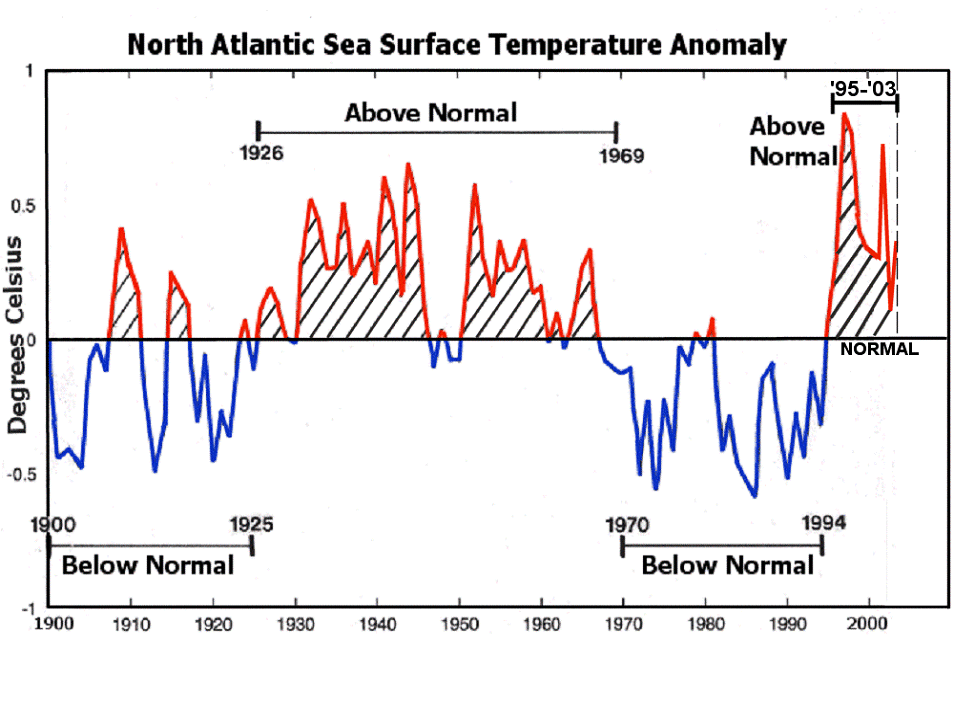
Dr. Bill Gray at Colorado State and Dr. Chris Landsea (NOAA) have done extensive research into North Atlantic SST regimes related to the North Atlantic Thermohaline Circulation. What they've found is that the thermohaline circulation "conveyor belt" has periods when it speeds up or slows down, each lasting from 20 to 40 years. These cycles in the thermohaline circulation result in periodic cooling and warming of the North Atlantic Ocean tropical regions, as seen in Image 1, below. There are clearly-identifiable warm and cold North Atlantic SST regimes. The Atlantic SSTs averaged cooler than normal from 1900-1925 and from 1970-1994 (two 25-yr periods) and warmer than normal from 1926-1969 and 1995-present.
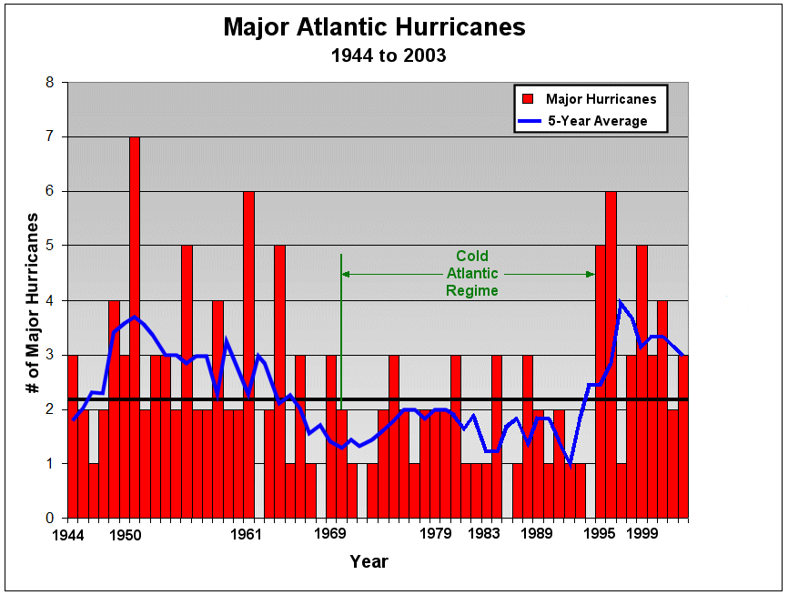
As you know, hurricanes derive their energy from the heat of the oceans. The warmer the water, the more energy available. What Dr. Gray and Dr. Landsea found was that there was a strong correlation between major hurricane activity and Atlantic SST regime, as indicated in Image 2, below. Specifically, they found that there are about twice as many major hurricanes during warm Atlantic SST regimes as in cold Atlantic SST regimes.
Image
1
Image 2
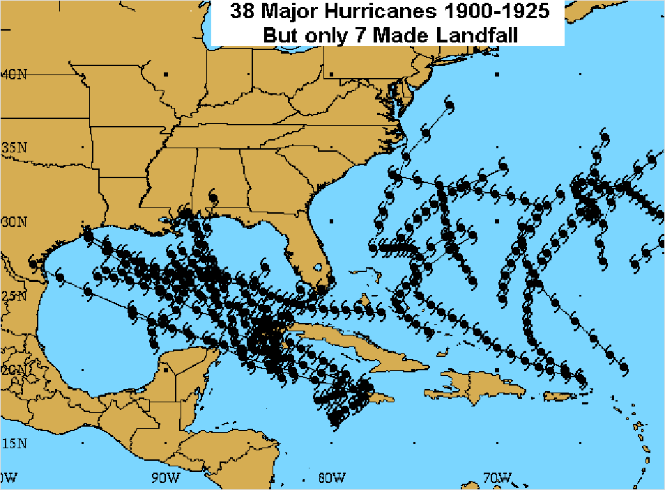
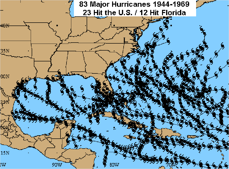
The differences between Warm and Cold regimes can be seen quite graphically below in Image 3 and Image 4. Note that I have plotted only the parts of the tracks of each storm whey they were at major hurricane intensity. Observe the many short-track major hurricanes. I didn't post the image from 1970-1994, but during that 25-year cold regime there were only 38 major hurricanes with 10 landfalls, pretty much the same as from 1900-1925. But look at the difference during a 25-yr period of the last warm Atlantic SST regime in Image 4. There were more than twice as many major hurricanes, many with quite long tracks, indicating more favorable conditions for development.
Image
3
Image 4
Now if you've been observant, you would have noted quite a dramatic difference in Florida and east U.S. coast landfalls in the two images above. The difference is shown quite dramatically in Image 5 and Image 6, below. Keep your eyes on the Florida Peninsula. Note that during the last two cold regimes that the Florida Peninsula was hit by only 1 or 2 major hurricanes each regime.
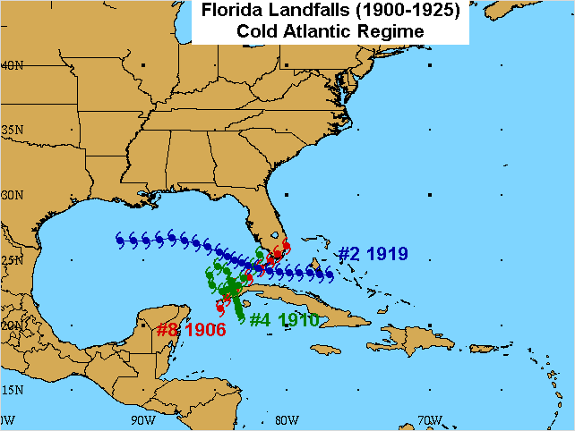
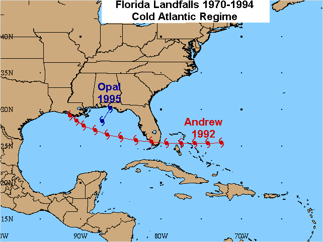
Image
5
Image 6
But what happens when the Atlantic heats up (as it is doing now) with respect to Florida landfalls? Look at Image 7, below. During a 25-year period from 1944-1969, Florida was hit by 12 major hurricanes - that's one every 2 years! Scary, isn't it?
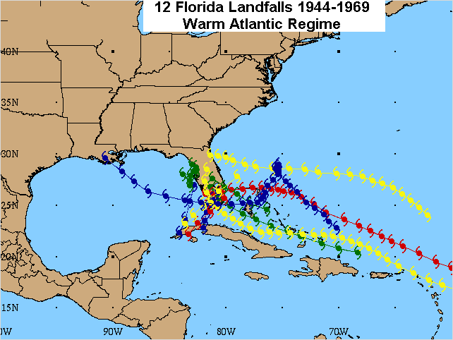
Image 7
As you saw in Image 1, above, the North Atlantic may be embarking on a multi-decade period of above-normal SSTs, similar to the period from 1926 to 1969. So we might expect a significant increase in major hurricane development. In fact, from 1995 to 2003 there have been 32 major hurricanes! Fortunately, only 3 of those made landfall. Climatology would suggest that 1/3 of all major hurricanes strike the U.S., so we've been very lucky that 3 and not 10 major hurricanes made landfall here in the past 9 years. But our luck (and especially Florida's) may be coming to an end.
There may be a good reason that 29 of those 32 major hurricanes have recurved out to sea in the past 9 years. The reason is that other factors have led to a weaker Bermuda high and a protective east U.S. coast trof. This has been due to a persistent Negative North Atlantic Oscillation (NAO) from 1995-2003. When the NAO is negative, the Greenland low sinks south and the Bermuda high shrinks and shifts east, leading to lower trade winds, less shear, and early recurvature of storms in the Atlantic. But there's a significant Pacific connection that I haven't discussed - the Pacific Decadal Oscillation (PDO). See Image 8, below. The temperatures in the North Pacific also tend to fluctuate in regular cycles, from warm phase to cold phase. It's when the cold-phase PDO combines with a warm Atlantic SST regime that all hell tends to break loose in the Atlantic, and particularly in Florida. Take a look at Image 8 and you'll see that the period from 1944-1975 was a prolonged period of cold-phase PDO combined with a prolonged warm North Atlantic SST regime. Also note that recent indicators suggest that the PDO is in the initial stages of a switch to a multi-decadal period of cold-phase.
What does that mean for the U.S.? Negative NAOs are more common during warm-phase PDOs, resulting in a weaker Bermuda high and early recurvatures. But with the PDO going cold-phase, the Bermuda high should begin to push farther west this year and in the coming decade or decades. It's the very same combination that occurred between 1944 and 1969 in Image 7, above. And, remember, Florida was hit by a major hurricane every 2 years from 1944-1969.
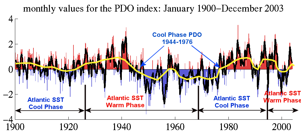
Image 8
So what might we expect for Florida the rest of this decade and in the next decade? See Image 9, below. The image below was constructed By Dr. Chris Landsea. He expects about 3 major hurricanes to hit Florida from 2004-2010 and again from 2010-2020. That's about 1 every 2-3 years. I agree with that conclusion. It all fits, prolonged warm Atlantic SST regime and prolonged cold-phase PDO leading to fewer El Ninos, more major hurricanes, and a significantly-enhanced east U.S. coast landfall threat in the coming decade and decades. Nowhere is the threat higher than in Florida.
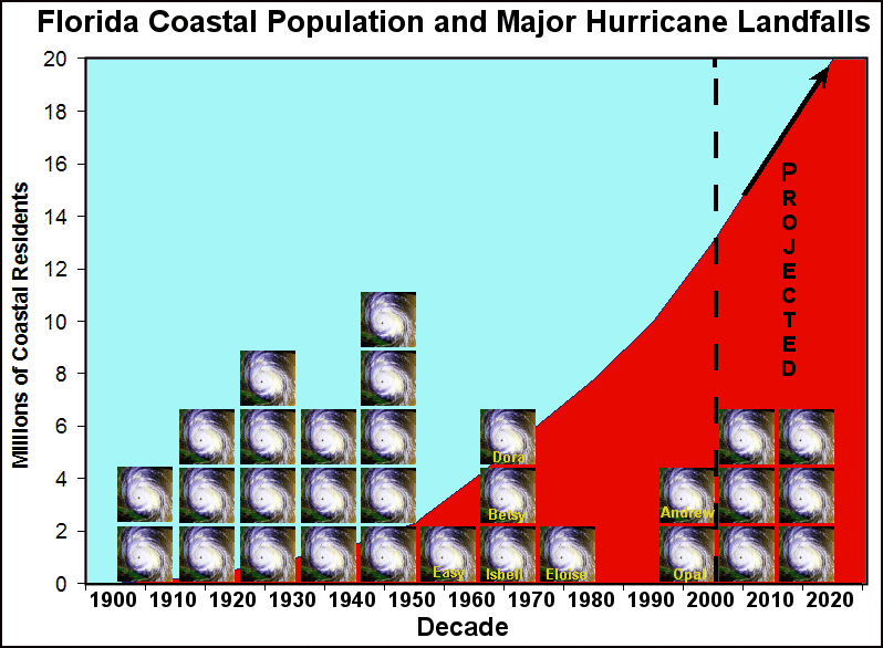
Image 9
So, as you see, the deck is not randomly shuffled each year with equal chances of a Florida landfall in any given season. We can identify specific patterns that may significantly enhance the chance of landfall in Florida and along the southeast U.S. coast. And such a pattern is now developing. The deck is definitely stacked quite highly against Florida now. And with the explosive growth in population since the last wave of major hurricane landfalls in Florida, be prepared for damage like you've never seen before.